United States Department of the Interior
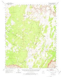
PARIA PLATEAU 15' [Map] United Stated Geological Survey
$ 24.00
$ 24.95
Long Name: USGS US Topo 15 - minute quadrangle map for Paria Plateau, AZ
Scale: 1:62,500
Content: Contours
Version Date: 1954
Regions: AZ
Nations: USA
Latitude: 36° 45' 0" N to 37° 0' 0" N
Longitude: 112° 0' 0" W to 111° 45' 0" W
Media: Paper
Format: Flat
Description: Paria Plateau, AZ
Survey Date: 1954
Print Date: 1978
Height In Inches: 21.400
Width In Inches: 17.100
Boundary Type: Quadrangle
Two Sided: No
Plates: 1
Pieces: 1
Languages: English 1055