Wide World Maps & MORE!
Regional Area Map of Yavapai & Coconino Counties Gloss Laminated [Map] Su Ling Heydrich
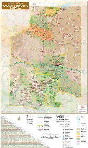
Regional Area Map of Yavapai & Coconino Counties is a shaded relief wall map of Yavapai and Coconino Counties, Arizona, USA. The map includes national scenic byways, scenic roadways, a milage chart, scale bars in miles and kilometers, and a complete legend.
The legend features numbered interstate highways, US highways, state highways, Indian highways, and non-Arizona state highways; routed interstate highways, principal paved highways, other paved highways, graded maintained roadways, and gravel roadways; traffic interchanges; interchange exit numbers; state boundaries and county boundaries; the Arizona Trail, national scenic byways, and scenic roadways; point-to-point distances in miles; tribal headquarters; county seats; municipalities by population ranges; public and private airports, major airports, and military airports; campsites, information centers, mountain peaks, points of interest, roadside rest areas, ski areas, and 24 hour emergency services; dry lakes, lakes, major rivers, rivers, streams and washes, and canals and aqueducts; and surface management for Indian reservations and communities, national forests, national monuments, national parks, wilderness areas, wildlife refuges, and US military facilities.
31050LAM