No Products in the Cart
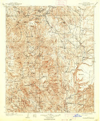
USGS topographic map of Bradshaw Mountains, AZ, at 1:125000 scale. 19 x 22 inches size - LAMINATED, Foldable but ships rolled. Perfect back road travel, treasure hunting, hiking exploring, historical reference, and decorative display. Ask us about custom enlargement, mounting and framing options. Cities, towns, villages: Potato Patch,Groom Creek,Rock Springs,Chilean Mill,Fort Misery,Burro John,Tip Top (historical),Packer,Spring Valley,McNary Place,Cordes Lakes,Breezy Pines,Minnehaha,Ocotillo,South Fort,Hooper,Crown King,Ponderosa Park,Venezia,Arcosanti,Humbug,Goodwin,Lehman Mill,Poland Junction,Dandrea,Lapham,Mayer,Paxton Place,Baldwin Place,East Fort,Cordes Junction,Bumble Bee,Black Canyon City,Bradshaw City,Gillette,Cordes,Cleator,Walker,Copperopolis,Briggs,Columbia
 As Seen On TV