MyTopo
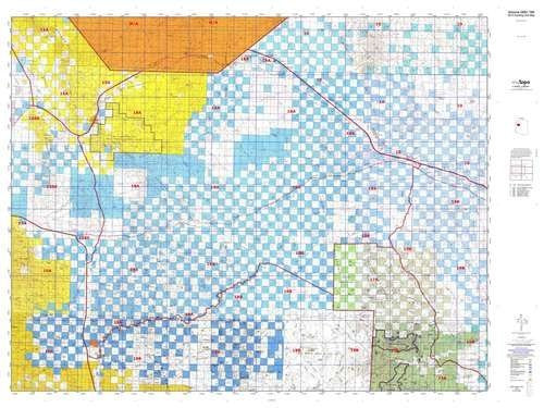
MyTopo Arizona 18A Hunt Area / Game Management Units (GMU) Map, 48" x 36", Greyscale, Smooth Finish, Topographic Map [Map]
Arizona GMU 18A, 2021 Hunting Unit Map, 48" x 36"
MyTopo Hunt Area / Game Management Unit (GMU) Maps are 1:100,000-scale maps using the Bureau of Land Management Land Status base maps. These maps include public land ownership boundaries, topography, roads, and key terrain features. The selected State hunt unit or game management unit boundary is overlaid on the BLM base.
New Road Updates for 2013: MyTopo GMU maps now contain updated 2013 National Forest and public land roads sourced directly from the US Forest Service and other government agencies.
New Tank and Water Source Locations for 2014: Arizona GMU maps show official Arizona Game and Fish water source locations (tanks, reservoirs, and springs)
- Species: All.
- Map Size: 48" × 36".
- Scale: 1:100,000
- One-sided, self-cover, plastic folded map.
- Hunting unit map of Arizona Game Management Unit 18A with topographic lines and unit boundaries. This topo map features UTM / MGRS and Latitude/Longitude grids, plus public land ownership. It comes folded on waterproof paper.
- This map contains the following named places: 86337, 86401, 86411, 86437, AIC Dam, Alabama Mine, Antares, Antelope Wash, Anvil Rock, Anvil Rock Ranch, Apache Creek, Aquarius Mountains, Ash Creek, Ash Fork Division, Aubrey Valley, Audley, Austin Peak, Bear Mountain, Big Dam, Biscuit Hill, Black Butte, Black Mountain, Blue Tank Wash, Blye Canyon, Bottleneck Wash, Bottleneck Windmill, Brushy Basin, Buck Dam, Cane Springs Wash, Canyon Mouth Dam, Cedar Basin, Cedar Basin Canyon, Cedar Wash, Century Mine, Cherokee, Cherokee Point, Chino Point, Chino Station, Chino Valley Ranger District, Chino Wash, Cienega Ranch, Cofer Dam, Cone Wash, Cooksie Dam, Copper Giant Mine, Corner Dam, Cornwall Basin, Cottonwood Cliffs, Cottonwood Creek, Cottonwood Mountains, Cow Creek, Cowden Ranch, Cross Mountain, Cross Mountain Dam, Crozier, Dairy Mountain, Dam Number One, Dam Number Two, Dead Horse Dam, Dean Mine, Dean Peak, Deer Lodge, Deer Mountain, Democrat Mine, Dennys Ranch, Devils Hump, Divide Canyon, Double O Ranch, Dripping Springs Canyon, Dunbar Mine, E L Camp, East Ash Creek, End Water Corral, Enterprise Mine, Farrel Mountain, Ferguson Ridge, Flag Mine, Fork Rock Creek, Fort Rock Ranch, Fox Dam, Frost Mine, Getz Ranch, Gobbler Knob, Gold King Mine, Gonzales Wash, Grand Canyon Caverns, Graver Wash, Greeley Dam, Hackberry, Hackberry Mine, Hackberry Wash, Hair Clipper Wash, Hay Dam, Haystack Peak, Hibernia Canyon, Hibernia Peak, Horse Lake, H-Ranch, Hualapai Canyon, Hualapai Indian School Reserve, Hualapai Mountains, Hualapai Valley, Hunt Ranch, Hyde Park, Indian Head, Indian Health Station, Indian Hill, Indian Peak, Iron King Mine, Jackass Basin, Jackman Wash, Janes Butte, Juniper Mesa, Juniper Mesa Wilderness, Juniper Mountains, K Four Ranch, Kabba Mine, Kabba Wash, Keseha Ranch, Kesena Dam, Keystone Extension Mine, Knight Creek, Lake Mary, Last Minute Well, Laughing Jack Butte, Left Hand Moss Wash, Little Mesa, Lookout Wash, Lower Basin, Lower Simmons Peak, Lucky Dam, Luis Maria Baca Grant Float Number Five, Maggie Dam, McGarrys Wash, Meadow Lake, Merlo Mine, Mica Giant Mine, Mohon Camp, Mohon Mountains, Mohon Peak, Moss Wash, Mount Hope, Muddy Creek, Muddy Wash, Nelson, Nelson Canyon, New Water Line Camp, New Windmill, North Fork Walnut Creek, North Hackberry Mine, O RO Ranch, Odle Ranch, Old Military Trail, Orejana Dam, Orejano Peak, Padre Reservoir, Palomino Peak, Pan Dam, Panther Point, Peach Springs, Peacock Mountains, Peacock Peak, Penitentiary Mountain, Pica, Pica Camp, Pickett Corral, Pilgrim Wash, Pine Lake, Pony Mesa, Pyramid Rock, Railroad Embankment, Railroad Embankment Reservoir, Red Horn Canyon, Red Lake, Red Mesa, Red Mountain, Rhodes Canyon Dam, Rim Rock, Road Canyon Dam, Rock Canyon, Rock House, Round Valley Ranch, S H Peak, Sandstone Camp, Section One Well, Seligman, Seligman Dam, Seligman Kampgrounds of America, Serendipity Mountain, Seventyfour Plains, Short Creek, Slate Mountain, Slurry Pond Number One Dam, Snow Mountain, Soto Dam, South Fork Walnut Creek, Spreader Dike, Squaw Peak, Standard Mineral Mine, Sugarloaf Peak, Sunrise Peak, Sunshine Mine, Taylor Ranch, Three Sisters, Timber Wash, Tin Mountain, Tom Bacon Lake, Triangle N Camp, Triangle U Ranch, Trinity Mountain, Trout Creek, Truxton, Tuckayou Wash, Turkey Creek, Twin Buttes, Upper Hidden Simmons Gonzales, Valentine, Valle Vista Golf Club, Victoria Mine, W F Cattle Company Dam, Wagon Bow Ranch, Wagon Wheel Wash, Walapai, Walker Peak, Walkover Mine, Walnut Creek Ranger Station, Walnut Creek Work Center, West Mesa, Wheeler Wash, Wild Cow Campground, Willow Creek, Windmill Ranch, X Bar One Ranch, Yampai, and Yavapai Ranch.


