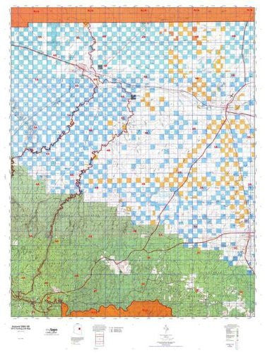
Arizona GMU 4B, Hunting Unit Map, 36" × 48"
MyTopo Hunt Area / Game Management Unit (GMU) Maps are 1:100,000-scale maps using the Bureau of Land Management land status base maps. These maps include public land ownership boundaries, topography, roads, and key terrain features. The selected state hunt unit or game management unit boundary is overlaid on the BLM base.
New Road Updates: MyTopo GMU maps now contain updated National Forest and public land roads sourced directly from the US Forest Service and other government agencies.
New Tank and Water Source Locations: Arizona GMU maps show official Arizona Game and Fish water source locations (tanks, reservoirs, and springs).
This topographic surface management map covers all of AZ Game Managment Unit 4B. It has been assembled using USGS and BLM mapping data with a red game management unit boundary overprint. It features surface management data, varying topographic contour intervals, as well as lat/long and UTM grid coordinates.
- All.
- Map Size: 36" × 48"
- Hunting unit map of Arizona Game Management Unit 4A with topographic lines and unit boundaries. This topo map features UTM / MGRS, Latitude / Longitude grids, and public land ownership. It comes folded on waterproof paper.
- This map contains the following named places: Aja Ranch, Alder Lake, Angell, Antelope Lake, Apache Butte, Apple Ranch, Aripine, Arizona Ranch, Aspen Lake, Aspen Recreation Area, Babbit Winter, Babbit Winter Ranch, Barber Lake, Battle of Big Dry Wash Historical Marker, Battle of Big Dry Wash Historical Monument, Bear Canyon Lake, Bear Canyon Lake Recreation Area, Beaver Valley Estates, Big Windmill, Blevins Lake, Blevins Ranch, Blue Ridge, Blue Ridge Boat Launch, Blue Ridge Campground, Bonita Creek Estates, Borderland Trading Post, Brigham City, Brody Hills, Buck Springs Cabin, Bush Cabin, Bushman Acres, C.C. Cragin Reservoir, Campo Bonito, Canyon Diablo, Canyon Diablo Reservoir, Carr Lake, Carr Lake Trailhead, Chavez Mountain, Chevelon Butte, Chevelon Canyon Campground, Chevelon Canyon Lake, Chevelon Lake Campground, Chevelon Ranger Station, Chevelon Work Center, Chevelon-Heber Ranger Station, City of Winslow Wastewater Treatment Plant, Clear Creek Lake, Clear Creek Reservoir, Clint Wells Campground, Clintons Pool, Clints Well, Corner Lake, Cow Lake, Crandall Peak, Crandell Ranch, Crater Lake, Daze Lake, Dead Horse Point, Deer Lake, Dennison, Double Cabin, Drew Canyon Trailhead, Dry Lake, Dude Lake, Dudley Lake, Duke City Logging Camp, Duran Ranch, Durfee Corral, Durfee Crossing, Dutch Joe Lookout, Dutch Joe Ranch, Dye Ranch, East Sunset Mountain, East Windmill, Ellsworth Ranch, Fidel Windmill, Five Mile Reservoir, Flake Ranch, Flake Windmill, Flat Top Butte, Flattop Hill, Flattop Windmill, Flying Butte, Forest Lakes Estates, Forest Lakes Trailhead, Four Section Windmill, Fourmile Knoll, Gibson Ranch, Graveled Hill, Halfway Ranch, Hall Point, Halter Cross Ranch, Heber, Heber Dump, Heber Work Center, Heber YCC, Hewitt Ranch, Hibbard, Hidden Cove Golf Course, Hidden Lake, Hillcrest Mobile Home Park, Holbrook, Holbrook Country Club, Holbrook Petrified Forest Kampgrounds of America, Holbrook Plaza Shopping Center, Hopi Industrial Park, Hopi-Winslow District, Hunt Park, Indian Rock, Jeffers Ranch, John Hunt Cabin, Joseph City, Kargas Mobile Home Park, King Phillip Guzzler, Lakeside Ranger District, Larson Ridge Trailhead, LDS Ranch, LeChee, Lee Mountain, Lerous Substation, Leupp Corner, Lewis Well, Linden Windmill, Lisitzky Subdivision, Little Nelson Lake, Little Rock Lake, Lone Pine Land Fill, Long Lake, Lower Tillman, Manila, Marcou Mesa, Marshall Well, McHood Park, Mesita Knoll, Meteor City, Mitchell Windmill, Monument Hill, Moonlight Bay Reservoir, Moqui, Mormon Crossing, Morris Windmill, Mud Lake, Nagel Logging Camp, Navajo County Fairgrounds, New Well, Newman Point, Ninemile Corral, North Park Plaza Shopping Center, Overgaard, Palomino Lake, Patrick Pond, Penzance, Phoenix Park, Pin Head Knoll, Pine Meadows Country Club, Pinto Lake, Point Lookout, Points of Wildcat, Possum Point, Pothole, Rattlesnake Point, Red Hill, Red Knoll, Rincon Ranch, Robinson Trail Crossing, Rock Station, Rocking Chair Ranch, Rocky Point Recreation Area, Rosedale Heights, Ryan Ranch, Saul Point, Schoens Crossing, Schoens Lake, Second Knolls, Second Mesa Campground, Sevenmile Windmill, Sheza Butte, Shumway, Shumway Butte, Sierra Plaza Subdivision, Sink Hole Lake, Sitgreaves National Forest, Sixmile Windmill, Snowflake, Snowflake Division, Snowflake Landing, Snowflake Municipal Golf Course, Solomon Butte, South Well, Spillway Campground, Standing Horse Mesa, Stone House, Sugarloaf, Sundown Girls Ranch, Sundown Mobile Home Park, Sunset City, Sunset Crossing, Table Mountain, Tall Timbers County Park, Tatum Baca, Taylor, Tenmile Cedars, The Box of Sevenmile, The Box of Tenmile, The Old Fort Historical Monument, Thomas Windmill, Tillman Ranch, Town of Snowflake, Town of Snowflake Wastewater Treatment Plant, Town of Taylor, Tucker Mesa, Turkey Lake, Twentymile Hill, Twin Lakes, V K Windmill, Walker Lake, Wallace Administrative City, Wallace Forest Service Facility, Walnut Ranch, West Sunset Mountain, West Windmill, West Winslow, Whitted Place, Winslow, Winslow City Park, Winslow Municipal Well Field, Winslow Tract, Winslow West, Winslow-Holbrook Division, Wolfe Ranch, Wood Pond Campground, Woods Canyon Lake, Woods Canyon Lake Boat Launch, Woods Canyon Lake Recreation Area, Woods Trailhead, Wyrick Ranch, Zeniff, and Zeniff Substation.
 As Seen On TV