Wide World Maps & MORE!
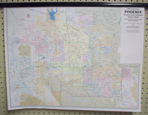
Metropolitan Phoenix Hazards and Warnings Paper/Non-Laminated Wall Map
This is a very specialized map that is designed to bring together a generalized metropolitan area view of several different kinds of environmental information important for many professionals.
Flood Hazards -- This map shows in blue the FEMA (Federal Emergency Management Agency) 3Q Flood Data scaled to a metropolitan area map. It also provides the user with a quick reference to the official FEMA folio maps.
Airport/Aircraft Noise -- The map geographically shows in yellow an approximate interpretation of the 65 decible sound level contour information submitted to the Arizona Department of Real Estate.
Superfund Sites -- It geographically shows in purple 30 important sites based on information compiled by the ADEQ (Arizona Department of Environmental Quality).
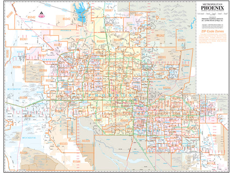
This large metropolitan Phoenix area wall map shows the residential street network and labels arterial (major) streets and freeways, as well as locating communities, river channels, canals, and railways. It is popular for general reference and for locating businesses which are normally found on the arterial and collector streets. The black and white image allows you to add your own colors for locations, areas, and zones. The grid corresponds to the index in the Phoenix Yellow1 Street Atlases and other Phoenix Mapping products for easy cross-reference. This is a convenient and useful at-a-glance reference ready for highlighters, sticker dots or arrows, or graphic tape.
Paper, one-sided wall map.
Size: 36" × 28"
- This is a very specialized map that is designed to bring together a generalized metropolitan area view of several different kinds of environmental information important for many professionals.
- The blue. yellow, and purple overprint clearly shows FEMA (Federal Emergency Management Agency) 3Q Flood Data, 65 decible sound level contour info, and ADEQ (Arizona Department of Environmental Quality) Superfund sites respectively.
- Shows major streets (arterial) and intermediate streets (collector)
- The black and white image allows you to add your own colors for locations, areas, and zones.
- The map is a convenient and useful at-a-glance reference ready for highlighters, sticker dots or arrows, or graphic tape.