MyTopo
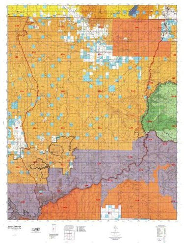
Arizona 13A Hunt Area / Game Management Unit (GMU) Map
Arizona GMU 13A, Hunting Unit Map, 36" × 48"
MyTopo Hunt Area / Game Management Unit (GMU) Maps are 1:100,000-scale maps using the Bureau of Land Management Land Status base maps. These maps include public land ownership boundaries, topography, roads, and key terrain features. The selected State hunt unit or game management unit boundary is overlaid on the BLM base.
New Road Updates: MyTopo GMU maps now contain updated National Forest and public land roads sourced directly from the US Forest Service and other government agencies.
New Tank and Water Source Locations: Arizona GMU maps show official Arizona Game and Fish water source locations (tanks, reservoirs, and springs).
This topographic surface management map covers all of AZ Game Managment Unit 13A. It has been assembled using USGS and BLM mapping data with a red game management unit boundary overprint. It features surface management data, varying topographic contour intervals, as well as lat/long and UTM grid coordinates.
- Waterproof paper, one-sided folding map.
- Scale: 1:100,000.
- Species: All.
- Map Size: 36" × 48"
- Hunting unit map of Arizona Game Management Unit 13A with topographic lines and unit boundaries. This topo map features UTM / MGRS and Latitude / Longitude grids, plus public land ownership. It comes folded on waterproof paper.
- This map contains the following named places: Andrus Point, Ann Pond, Antelope Knoll, Antelope Knoll Pond, Arizona Inspection Station, Arkansas Ranch, Berry Knoll, Big D Reservoir, Big Dike Reservoir, Big Sand Wash, Big Warren Reservoir, Bitter Seeps Wash, Black Canyon Reservoir, Black Knolls, Black Point Reservoir, Blue Knolls, Bobcat Reservoir, Booze Crossing, Boysag Point, Brown Knoll, Browns Reservoir, Bull Point, Bulrush Point, Bulrush Wash, Bundy Ponds, Burnt Canyon Point, Caanon Reservoir, Cable Crossing, Cane Beds, Cattle Guard Pond, CCC Trail Reservoir, Cecil Pond, Cedar Knoll, Cedar Pond, Cement Dam Reservoir, Chefs Pond, Chic Pond, Chikapanagi Mesa, City of Hildale, City of Kanab, Clayhole Wash, Cold Spring Point, Cold Spring Wash Pond, Colorado City, Corral Pond, Cottonwood Creek, Cottonwood Point, Cottonwood Point Wilderness, Cottonwood Wash, Cowboy Butte, Craig Ranch, Craigs Knoll, Crosby Reservoir, Dead Horse Mesa, Deadman Knoll, Death Valley Lake, Deer Creek, Diamond Butte, Dike Pond, Ditch Pond, Dixie Knoll, Dolittle Pond, D-Six Pond, Earl Pond, Earl Reservoir, Ed Lamb Point, Esplins Corral, Fence Pond, Ferg Pond, Field Pond, Findlay Knolls, Fishtail Mesa, Flat Top, Flat Tops, Flatiron Butte, Flattop Reservoir, Fredonia, Graham Ranch, Grand Canyon National Game Preserve, Grassie Point Reservoir, Griffith Knoll, Guaranteed Pond, Gyp Reservoir, Hack Reservoir, Hades Knoll, Hancock Knoll, Hancock Knolls, Harolds Reservoir, Hat Knoll, Havasu Creek, Heaton Knolls, Heaton Reservoir, Hells Hole, Hildale, Hualpais Village, Hundred and Twentyeight Mile Creek, Hundred and Twentyseven Mile Creek, Hundred and Twentytwo Mile Creek, Indian Knoll, Indian Moccasin, J W Spendlove Reservoir, Jackson Reservoir, James Pond, Jodys Lake, Johnson Wash, Jones Hill, Jumpup Cabin, Jumpup Divide, Kaibab, Kaibab Indian Reservation, Kanab Creek, Kanab Creek Wilderness, Kellands Pond, Keller Pond, Kent Ranch, Kenworthy Ranch, Kinney Point, Kirk Pond, Lakes of Short Creek, Lang Pond, Langs Run, Langston Reservoir, Little Boulder Pond, Little Clayhole Reservoir, Little Clayhole Wash, Little Toroweap Reservoir, Loco Point, Lone Butte, Lonesome Valley Pond, Long Mesa, Lost Spring Mountain, Lost Spring Wash, Marshall Ranch, Maryland Knoll, Matkatamiba Mesa, McBryde Reservoir, McCullan Reservoir, McKee Point, Meeks Reservoir, Moccasin, Moccasin Mountains, Moriah Knoll, Mount Akaba, Mount Burro, Mount Emma, Mount Logan, Mount Logan Wilderness, Mount Sinyella, Mount Spoonhead, Mount Trumbull, Mount Trumbull Wilderness, Mount Wodo, Mule Point Pond, Nagles Crossing, Navajo Pond, Nixon Ranger Station, North Fork Robinson Wash, North Whitmore Point Pond, Nutter Pond, Nyborg Pond, Old Movie Fort, Olo Mesa, Petty Knoll, Pipe Spring National Monument, Pipe Valley Wash, Point Rock, Pugh Knoll, Racetrack Knoll, RCA Pond, Red Blanket Ranch, Red Flat Pond, Reeds Reservoir, Resource Pond, Road Pond, Road Reservoir, Robinson Reservoir, Robinson Wash, Rock Canyon Reservoir, Rock Crossing, Rock Crossing Reservoir, Rockhole Pocket Reservoir, Round Pond, Roys Pond, Sage Flat Reservoir, Salt Pond, Sand Wash, Schmutz Ranch, Seven Knolls, Seven Knolls Bench Reservoir, Shale Rock Pond, Sheep Pockets Reservoir, Sheep Pockets Trough, Sims Reservoir, Sinkhole Pond, Sinkhole Reservoir, Sinyella Mesa, Sixmile Village, Slide Mountain, Slide Point, Snake Pond, South McBryde Pond, Spencer Knoll, Spooks Knoll Reservoir, Square Pond, Stock Pond, Sugar Pond, Sunshine Point, Supai, Swapp Reservoir, Temple Pond, The Black Rocks, The Cork, The Dome, The Lake, Tom Lamb Reservoir, Tony Pond, Topocoba Hilltop, Toroweap Lake, Toroweap Ranger Station, Town of Colorado City, Town of Fredonia, Trail Pond, Tuweep, Twin Butte, Twomile Corrals, Upper Antelope, Vulcan's Throne, White Pockets Windmill, Whitmore Point Pond, Wild Band Reservoir, Witch Pool, Woods Ranch, Woody Pond, Yellowstone Mesa, and Yumtheska Mesa.


![Arizona Road and Recreation Atlas [Paperback] Benchmark Maps - Wide World Maps & MORE!](http://maps4u.com/cdn/shop/products/81WodCcaVHL_large.jpg?v=1742587807)

