No Products in the Cart
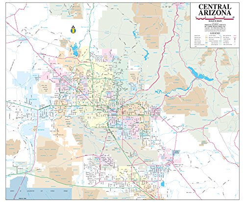
This wall map shows major (arterial) streets, rail and lightrail, and highways for the central region of the State of Arizona. Centered on the Phoenix Metropolitan area, it also shows most of Maricopa, Pinal, and parts of Gila and Yavapai counties. This is the perfect map to plan and track growing commercial markets in this economic hub of the Southwest.
The map is encapsulated in heavy-duty 1.7 mil laminate which makes the paper much more durable and resistant to the swelling and shrinking caused by changes in humidity. Laminated maps can be framed without the need for glass, so the frames can be much lighter and less expensive. Gloss Lamination features premium optically clear film which provides a high shine for dramatic color presentation. This is a convenient and useful at-a-glance reference ready for wet-erasable markers, self-adhesive dots or arrows, and/or graphic tape.
 As Seen On TV