Description
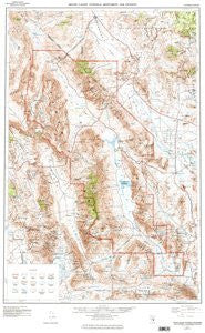
USGS's Death Valley National Monument and Vicinity, California and Nevada is a political, road, topographic, and recreation map all-in-one! The legend includes primary highways with hard surfaces; secondary highways with hard surfaces; light duty roads with hard surfaces or improved surfaces; unimproved roads; trails; U. S. routes; and state routes. Paper, one-sided wall map. Scale = 1:250,000; Contour Interval = 200' topographic; Supplemental Contour Interval = 100' topographic; Size = 24" x 39"; 100,000' Grids = California Coordinate System (Zones 4 and 5) and Nevada Coordinate System (Central Zone); 10,000m Grid = Universal Transverse Mercator (Zone 11); Projection = Transverse Mercator; Horizontal Datum = 1927 North American; Vertical Datum = 1929 National Geodetic
 As Seen On TV