No Products in the Cart
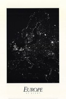
Europe At Night is a 24x36 inches (61x91cm) black & white satellite map. In contrast to daytime images, where only natural features are easily visible, the activities of Europeans at night are readily traced in this mosaic of images taken over the period 1985-89 by U.S. Air Force weather satellites. This unique image reveals the extent of light energy use, especially in the densely-populated Northern parts of Europe. Even in the south, Spain and Italy are framed by the thread of coastal habitation.
One-sided paper print.
 As Seen On TV