Description
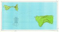
USGS's Topographic Map of the Manua Islands, American Samoa is a political, road, topographic, sounding, bathymetric, and recreation map all-in-one! The legend includes trails.
Long Name: MANUA ISLANDS, AS
Scale: 1:24,000
Content: Contours
Version Date: 1963
Regions: AS
Countries: ASM;USA
Latitude: 14° 17' 30" S to 14° 9' 0" S
Longitude: 169° 41' 30" W to 169° 24' 0" W
Media: Paper
Format: Flat
Description: MANUA ISLANDS, AS
Survey Date: 1963
Print Date: 1965
Height In Inches: 30.020
Width In Inches: 55.640
Boundary Type: Quadrangle
UTM Grid: Tic
Horizontal Datum: American Samoa 1962
Vertical Datum: Mean Lower Low Water; Mean Sea Level
Two Sided: No
Plates: 1
Pieces: 1
Languages: English
 As Seen On TV