National Geographic Maps
The Territorial Growth of the United States Ready-to-Hang [Map] Abel Buell
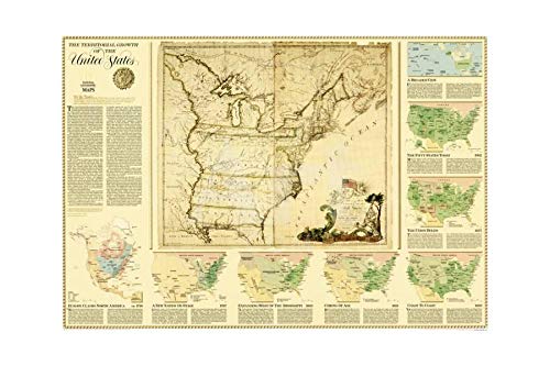
The centerpiece of this fascinating collection of maps is a reproduction of a 1783 map by Connecticut engraver Abel Buell. That map presents, as though settled, an issue that threatened to pull the new nation apart. Who controlled the West, the area beyond the Appalachians! The Territorial Growth of the United States is an excellent overview describing the issues, conflicts, and opportunities that were at the center of how land was acquired, usurped, and annexed as the United States took form. It includes maps that show Europe Claims in North America ca 1750, A New Nation on Stage 1787, Expanding West of the Mississippi 1803, Coming of Age 1821, Coast to Coast 1850, The Union Holds 1877, and the Fifty States Today 1987.
This map print displays sharp, vivid images with a high degree of color accuracy. A member of the versatile family of map prints, this high-quality reproduction represents the best of both worlds: quality and affordability. Gloss Lamination features premium optically clear film which provides a high shine for dramatic color presentation. The gloss laminated map is a convenient and useful at-a-glance reference ready for wet erase or alcohol erase markers, sticker dots or arrows, or graphic tape.
Ready-to-Hang maps have rails at the top and the bottom to keep the map flat against the wall with two loops on the top rail for easy hanging. A package of wall hooks and nails completes the set.
- Ready-to-hang, gloss laminated, two-sided wall map.
- Size: 44" × 31"