No Products in the Cart
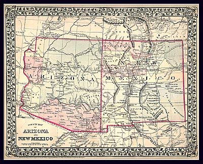
This is a special high-resolution color reproduction of a very rare original territory map of Arizona and New Mexico found in an old atlas at the US Library of Congress. Engraved and published by S. Augustus Mitchell in 1879, it shows the communities and routes of the time.
The map is encapsulated in heavy-duty 1.7 mil laminate which makes the paper much more durable and resistant to the swelling and shrinking caused by changes in humidity. Laminated maps can be framed without the need for glass, so the frames can be much lighter and less expensive. Satin Lamination features glare-reducing qualities that provide a soft sheen. A satin finish is best suited for backdrop prints and displays receiving indirect, bright lighting.
Ready-to-Hang maps have rails at the top and the bottom to keep the map flat against the wall with two loops on the top rail for easy hanging. A package of wall hooks and nails completes the set.
 As Seen On TV