MyTopo
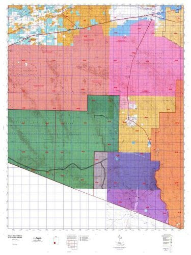
Arizona GMU 40B East Hunt Area / Game Management Unit (GMU) Map
Arizona GMU 40BE, Hunting Unit Map, 36" x 48"
MyTopo Hunt Area / Game Management Unit (GMU) Maps are 1:100,000-scale maps using the Bureau of Land Management Land Status base maps. These maps include public land ownership boundaries, topography, roads, and key terrain features. The selected State hunt unit or game management unit boundary is overlaid on the BLM base.
New Road Updates: MyTopo GMU maps now contain updated National Forest and public land roads sourced directly from the US Forest Service and other government agencies.
New Tank and Water Source Locations: Arizona GMU maps show official Arizona Game and Fish water source locations (tanks, reservoirs, and springs).
- One-sided, self-cover, plastic folded map
- Hunting unit map of Arizona Game Management Unit 40B-East with topographic lines and unit boundaries. This topo map features UTM / MGRS and Latitude / Longitude grids, plus public land ownership. It comes folded on waterproof paper.
- This map contains the following named places: 85321, 85341, Adobe Windmill, Agua Dulce Mountains, Aguajita Wash, Aguila Mountains, Ajo, Ajo Copper Mines, Ajo Country Club, Ajo Division, Ajo Landfill, Ajo Peak, Ajo Range, Ajo Recreation Center, Alamo Canyon, Alamo Wash, Alpha, Antelope Hills, Arch Canyon, Arizona Highway Maintenance Gila Bend Yard, Arkansas Mountain, Augie's Quail Trail Recreational Vehicle Resort, Aztec, Aztec Hills, Baker Mine, Baragan Wash, Barajita Valley, Batamote Mountains, Bates Mountains, Bates Well, Bell Mine, Bender Wash, Black Butte, Black Gap, Black Mountain, Blindman Butte, Blue Plateau, Bluebird Mine, Boulder Canyon, Boy Scout Campgrounds, Bryan Mountains, Bud Walker Park, Cabeza Prieta Game Range, Cabeza Prieta National Wildlife Refuge, Cabeza Prieta Wilderness, Camelback Mountain, Canyon Diablo, Cardigan Peak, Cerro Blanco, Chagit Vo, Charco, Cherioni Wash, Chia Canyon, Chico Shunie, Chico Shunie Arroyo, Chico Shunie Hills, Chico Shunie Temporal, Childs, Childs Mountain, Childs Ranch, Childs Valley, Chiulikam, Cinder Mountain, Cipriano Hills, Clanton Wash, Coffeepot Mountain, Concentrator Hill, Copper Canyon, Copper Mountain Mine, Crater Range, Cuerda de Lena, Daniels Arroyo, Darby Arroyo, Dateland, Dateland Highway Yard, Davidson Canyon, Deer Hollow, Dennison Picnic Ground, Diablo Mountains, Diaz Peak, Diaz Spire, Dos Playas, Dowling Ranch, Eagle Canyon, Estes Canyon, Farmers Canal, Fort Horn Monument, Gadsden Peak, Gakolik Mountains, Gibson, Gibson Arroyo, Gibson Neighborhood Park, Gila Bend, Gila Bend Division, Gila Bend Substation, Gila River Ranch, Granite Mountains, Grass Canyon, Greenway Cross, Griswells, Growler Canyon, Growler Mountains, Growler Peak, Growler Valley, Growler Wash, Gu Vo, Gu Vo District, Gu Vo Hills, Gunsight, Gunsight Hills, Gunsight Valley, Gunsight Wash, Half White Mountain, Halfway Corral, Hat Mountain, Hoa Murk, Hoodoo Wash, Horn, Horn Cotton Gin, Hotason Vo, Hummingbird Canyon, Ironwood Ranch, Jack in the Pulpit, John the Baptist, John the Baptist Mountains, Kino Peak, Kuakatch, Kuakatch Wash, La Abra Plain, Lake Towers, Lateral A, Lateral B, Lateral D, Levy Peak, Lime Hill, Little Ajo Mountains, Locomotive Rock, Lookout Mountain, Lost Cabin Mine, Lukeville, Malpais Hill, Manuels Well, Marine Mine, Martinez Mine, Mexican Town, Mica Mine, Midway, Midway Station, Midway Wash, Milton Mine, Montezuma Head, Monument Bluff, Mount Ajo, Needle Valley, New Cornelia Mine, New Cornelia Tailings Dam, Ninemile Peak, North Ajo Peak, O'Neill Hills, Organ Pipe Cactus Family Picnic Ground, Organ Pipe Cactus National Monument, Organ Pipe Cactus Wilderness, Organ Pipe Family Campground, Pack Rat Hill, Palo Verde Camp, Palomas, Papago Mine, Papago Mountain, Paradise Canyon, Park Valley, Pia Oik, Pia Oik Valley, Piedra, Pinacate Valley, Pinkley Peak, Pinnacle Peak, Pinta Sands, Pitahaya Canyon, Plaza Shopping Center, Port of Entry Lukeville, Pozo Redondo Mountains, Pozo Redondo Valley, Pozo Salado, Puerto Blanco Drive, Puerto Blanco Mountains, Quitobaquito, Quitobaquito Hills, Rasmussen Mine, Red Point, Rest Area Eighty-four T Two, Rest Area One Hundred Twentythree C, Rest Area One-hundred Twenty-nine MP, Rocky Point, Rowood, San Antonio Mine, Sauceda Mountains, Scarface Mountain, Schuchuli, Sears Point, Senita Basin, Sentinel, Sentinel Peak, Sentinel Plain, Sentinel Wash, Sheep Mountain, Sheep Peak, Sierra Pinta, Sikort Chuapo, Sikort Chuapo Mountains, Sikort Chuapo Wash, Siovi Shuatak, Smurr, Sonoran Desert, Sonoyta Mountains, South Gila Ditch, Stanwix, Stinson Peak, Surprise Mine, Sweetwater, Tartron, Tenmile Wash, Tepee Butte, The Adobe, The Lagoon, Theba, Theba Substation, Tillotson Peak, Tom Thumb, Twin Peaks, Valley of the Ajo, Victoria Mine, White Hills, White Mountain, Why, and Yolo Ranch


![Arizona Road and Recreation Atlas [Paperback] Benchmark Maps - Wide World Maps & MORE!](http://maps4u.com/cdn/shop/products/81WodCcaVHL_large.jpg?v=1742587807)


