No Products in the Cart
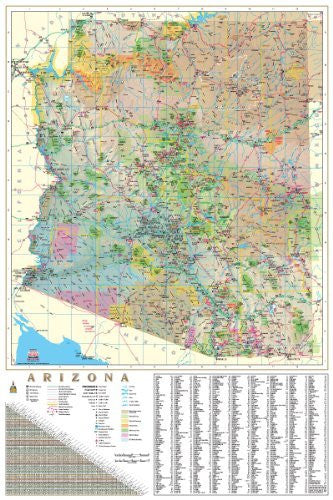
This is the wall map of Arizona that you've been waiting for! Featuring shaded relief, this map clearly defines counties, Native American lands, National Forests and Monuments, Wilderness Areas, scenic roadways, the Arizona Trail, and much, much MORE! Below the map inself are a comprehensive mileage chart and an exhaustive community index. The map also includes scale bars for both miles and kilometers. No office or classroom is complete without this map!
The legend shows interstate highways, principal paved highways, other paved highways, graded maintained roadways, gravel roadways, the Arizona Trail, state boundaries, county boundaries, national scenic byways, scenic roadways, point-to-point mileages, traffic interchanges, the state capital, county seats, cities and towns by population, sites or settlements, public airports, major airports, military airports, camp sites, entry ports, information centers, interchange exit numbers, mountain peaks with elevation, points of interest, roadside rest areas, ski areas, tribal headquarters, 24 hour emergency services, dry lakes, lakes, major rivers, rivers, streams and washes, canals and aqueducts, Indian reservations and communities, National Forests, National Monuments, National Parks, wilderness areas, wildlife refuges, and US military facilities. Highways are differentiated by interstates, U.S. highways, Arizona state highways, Indian routes, and other state highways.
One-sided dry erase laminated, one-sided wall map.
Size: 32" x 48"
 As Seen On TV