Description
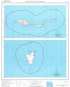
USGS's Channel Islands National Monument, California is a political, road, topographic, and recreation map all-in-one! The legend includes trails. The upper map of Anacapa Island measures 8"x3.5" and covers the area from Latitude 33° 59' 00" to 34° 02' 30" N and Longitude 119° 20' 00" to 119° 28' 00" W. The lower map of Santa Barbara Island measures 8"x4" and covers the area from Latitude 33° 26' 30" to 33° 30' 30" N and 118° 57' 30" to 119° 05' 30" W. Paper, one-sided wall map. Scale = 1:24,000; Bathymetric and Topographic Contour Interval = 40'; Size = 24" x 30"; 10,000' Grids = California Coordinate System (Zones 5 and 7); 1,000m Grid = Universal Transverse Mercator (Zone 11); Projection = Lambert Conformal Conic; Horizontal Datum = 1927 North American; Vertical Datum = 1929 National Geodetic
 As Seen On TV