Gloss Laminated Satellite Image Map of Antartica - Wide World Maps & MORE! - Book - Wide World Maps & MORE! - Wide World Maps & MORE!

Gloss Laminated Satellite Image Map of Antartica [Map] United States Geological Survey

SKU 12060G
$ 50.55
    Description

    Product Details

    • Product Number: 28468
    • Series: I-2284
    • Scale: 1:5,000,000
    • Alternate ID: GI2284T
    • ISBN: 978-0-607-79453-3
    • Authors: GEOLOGICAL SURVEY (U.S.)
    • Version Date: 01/01/1991
    • Countries: Antarctica
    • Media: Gloss Laminated Paper
    • Format: Flat
    • Survey Date: 1991
    • Print Date: 1991
    • Height In Inches: 42.000
    • Boundary Type: Quadrangle
    • Two Sided: No
    • Pieces: 1
    • Languages: English

    Additional Details

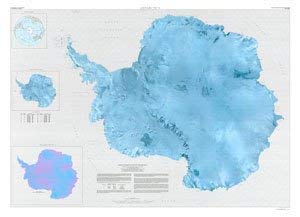
    • Description: Use this map of the entire Antarctica continent from a mosaic of satellite images to teach and learn about the physical geography of the continent.
    • Gloss Lamination features premium optically clear film which provides a high shine for dramatic color presentation. The gloss lamination makes this map a convenient and useful detailed reference ready for wet erase markers, sticker dots, or graphic tape.
    • 56"×42" gloss laminated, one-sided wall map.
    As Seen On TV

    How do you like the new site? If you would like to provide feedback, please click here.