No Products in the Cart
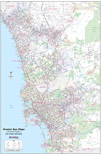
Updated for 2019 - sharp and functional wall map of Greater San Diego.
This large 48"×72" wall map offers the best of both worlds with a unique combination of detail and coverage. From Oceanside to the Mexico border and Ramona to La Jolla - the entire San Diego region is covered.
Every street is shown, with all major roads labeled. Freeways (with exit numbers), toll roads, airports, commuter rail lines, hospitals, colleges, parks, high schools, major points of interest, rivers, major terrain features, and current ZIP codes are all clearly indicated.
Ideal for the office, warehouse, classroom, or home. This jumbo wall map is laminated and ready to ship!
 As Seen On TV