No Products in the Cart
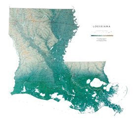
The gentle rolling landscape shown on the Louisiana map is a result of years of clays and silt being deposited by the Mississippi River. Remarkable Lake Pontchartrain is the largest estuary in southern Louisiana.
All of Raven's state wall maps display an incredible amount of detail, from cities, highways, and mountain ranges, to valleys, rivers, and small towns. Louisiana map elevations are represented by color, and this, in combination with their relief shading technique, gives the map a lush, 3-dimensional look.
Louisiana Map Dimensions: 45" x 41"
Louisiana Map Scale: 1:500,000 (1" = about 8 miles)
A laminated map can also be mounted and framed without using glass. This method of display helps keep the weight and cost of framing down, and is less reflective and easier to clean than glass.
Laminated maps are durable enough to pin onto the wall, yet flexible enough to be rolled and shipped in our sturdy cardboard tubes.
The lamination is a lightweight (1.7 mil) clear vinyl that can even be written on with dry erase markers (available at any office supply store or elsewhere on Amazon.com) and wiped clean with a soft cloth.
 As Seen On TV