No Products in the Cart
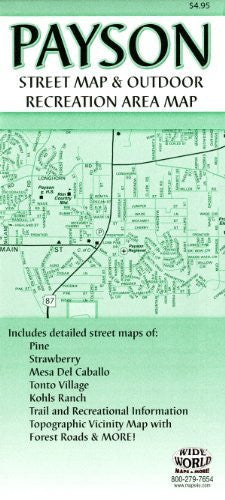
This is the map you demanded! This up-to-date street map is the first of its kind for the region. The obverse has a full street detail map of Payson, Star Valley, and the Tonto Apache Indian Reservation. Beneath the map are street indexes for Payson and Star Valley, Pine, Strawberry, Tonto Village and Kohl's Ranch, and Mesa del Caballo.
The reverse features a vicinity map showing the areas of each street map, plus the forest roads and trails in between. To the right of the vicinity map are individual street maps for Strawberry, Mesa del Caballo, Pine, and Tonto Village and Kohl's Ranch. Beneath the street maps is a Trails and Recreational Information table filled with airports, colleges, high schools, elementary/junior high/middle schools, golf courses, medical facilities, campground areas, trailheads, parks, points of interest, ranger stations/fire towers, and recreation sites.
 As Seen On TV